


Caspian Energy (CE): What could you tell about the results of the activity Fugro carried out in the first half of 2013?
Chris Mott, General Manager, Fugro Survey Ltd (Caspian): We have been very busy on several fronts. We have continued to support the installation of the Chirag Oil Project pipelines, being present on ROV support vessel TOPAZ Arrow; pipelay barge PLBH and the diving support vessel, DSV. These operations were dedicated to the Chirag Oil Project pipeline installation work. We have been providing three remotely operated vehicles, plus a full set of survey and positioning personnel and equipment to make sure that the pipeline is safely and accurately laid on the seabed. We are also participating in the installation of other oil-field equipment that will enable the oil to flow to the shore.
We are in the process of carrying out an AUV survey in the Absheron Field. AUV stands for “Autonomous Underwater Vehicle”. This system is operating from the vessel TOPAZ Triumph. We are conducting an 11,000km survey covering the whole field for future exploration and production activities. The results of the survey will be a very detailed map of the depth of the sea over the whole block. Water depth varies from approximately 100m to over 600m, so we are talking about deep water. We also provide information on the material the seabed is composed of (the soils). The bed of the Caspian Sea is full of features such as mud volcanoes and soft sediments. It displays other active geological processes. This means that full understanding of the seabed is very important before a design for gas-field can be elaborated. We will determine the water depth, we will determine the composition of the material of the seabed and its sensitivities, and we are also geophysically surveying below the seabed to determine the nature of the soil beneath the seabed to about 50 meters. This information informs design when laying pipelines on the seabed, installing platforms, wellheads or doing other work which interacts with the seabed.
We participated in an annual environmental survey in the Caspian Sea which is carried out to check that the seabed environment is not changing because of oil-gas activities. We are preparing to do some onshore geotechnical survey and geophysical survey work south of Baku for new developments and extensions to established developments.
We will be drilling boreholes on these sites and sending the soil samples that we take from these boreholes to our laboratories for analysis to find out what the properties of the soil are. We also will be carrying out tests on site of the soils in situ to determine other properties of the soil. These are the two ways that geotechnical testing is carried out. One way is to obtain actual samples of the soil from the site and bring them to the laboratory and perform tests in the laboratory under controlled conditions. The second uses instruments that are pushed into the soil. As instruments are being pushed through the soil they measure different parameters, such as the strength of the soil, and the friction of the soil, and the electric properties of the soil. The results of these tests are obtained immediately. This technique is known as cone penetration testing.
CE: Which new technologies and services have you introduced during operations performed on Absheron block?
Chris Mott: I have already talked about the AUV (autonomous underwater vehicle) survey. That is a leading technology and we are one of three or four commercial companies in the world that utilize it in very deep water. Fugro worldwide has a greater number of these AUVs than any other civil company in the world. We also, later this year, will be carrying out a geotechnical survey offshore in the deep water Absheron area. Because the water depth is great, we are bringing in some new technology to do this survey. Normally, we would employ a boat with a drilling rig mounted on it and the drilling rig would lower the drill bit on a drill string to the seabed and get the samples. But because the water depth is so great, the drill string would be too heavy. So we will import from the United States, Fugro’s Seabed Drill which is a self contained unit that is relatively light. We will lower it to the seabed. It will sit on the seabed and from there it will drill into and perform tests on the seabed. It is almost autonomous like the AUV but instead of having a long heavy drill string and a big derrick, all that is needed is a device capable of lowering the Seabed Drill along with its control lines to the seabed.
We developed, with an international oil company, a new way of inspecting existing pipelines on the seabed in shallow water which our client believes to be world-class and leading-edge. We have done this by adapting multi-beam echo sounders to look at each side of a pipeline in shallow water, using sound to create a picture of the pipeline to determine the position and the location of the pipeline in relation to the seabed. One can see whether it is exposed on the seabed, whether it has been covered by the seabed sediments, or whether there is a gap between the pipeline and the seabed. This work is carried out in shallow water. We would like to introduce these techniques to other operators because we believe that they could help them in the management of the integrity of their pipelines. This particular technique was developed last year.
CE: What could you tell about projects or plans that are planned to be completed by the end of the year?
Chris Mott: Well, the COP (Chirag Oil Project) project should be completed by the end of the year. The AUV survey will be probably still be ongoing at the end of the year in Absheron block. The pipeline inspection program is ongoing. It is not just a one time event. You have to keep investigating to see how the condition of the pipelines is changing. As to the onshore geotechnical work, the operational phase is just beginning so a fixed schedule has not yet been determined.
CE: Are there preliminary results on the survey carried out at Absheron block?
Chris Mott: It is probably too early to tell except that we do know that in the deep-water areas of the Caspian Sea the sediments are extremely soft.
CE: Which ecological principles do you follow when performing operations in the Caspian, especially in Chirag?
Chris Mott: Fugro has been accredited against the international environmental standards ISO 14001 and ISO 18001. It is our primary objective to enable everyone to work safely, to cause no damage to the environment and cause no damage to the equipment being used. We are very, very careful about how we conduct our business.
CE: What else can Fugro offer for the Caspian region from all those new technologies?
Chris Mott: The Fugro Group spends millions of dollars on research and development every year. Those dollars are spent, not on blue sky research and development, but on client focused solutions. We like entering into dialogue with our clients to understand their businesses and what their problems are within the area of our expertise. We spend our research and development effort on coming up with ways to solve those problems or to add value. I am not fully aware of all Fugro research and development effort but I do know that we are working to improving the way that subsea metrologies are carried out. Subsea metrology involves measuring accurately where the end of a pipeline is on the seabed and the position of the facility it is going to be connected to, so that jumpers and spools can be made to connect the two together. This is a very important part of offshore subsea construction, but is time consuming and therefore costly. For example, if a pipeline is laid from shore to an oil or gas field, it is laid down on the seabed. A platform or a well head has to be connected the pipeline. Very accurate measurements of the positions of the two pieces that have to be joined together are required in terms of position, orientation and rotation, so that a piece can be lowered to the seabed to connect the two together
We are working on some new technologies that will make the process more accurate faster and therefore more cost effective.
CE: Are tectonic movements of stratums taken into account when performing this work?
Chris Mott: Not at this stage. At the construction phase, all of those calculations and assessments have had to have already been done. We have experts in geo-consulting throughout the world. They are specialists in analyzing the seabed in terms of seismic risk. When there is an earthquake and the seabed moves, unstable sediments can be shaken loose and flow downhill. The Caspian Sea, for example, sometimes exhibits steep slopes. A seismic shock could shake the soils to cause them to flow rapidly down the slope. They can damage the facilities which lay in their path, which is why a very accurate and reliable risk assessment is required. If facilities are potentially in the way of such an event the engineering that has already been decided upon must be designed to avoid or withstand these events.
CE: Is there anything else that you would like to add in regard to things that we have not covered?
Chris Mott: Personally, I am very proud of the work that Fugro does in the Azeri sector of the Caspian Sea. I feel that we are genuinely providing our clients with a world-class service. We also believe that the value we add with our services is of real benefit to our clients. I would very much like the opportunity to offer our full range of services to all of the oil companies operating in the Caspian Sea.
CE: Does it mean that Fugro is a company that lends support to oil companies during drilling operation?
Chris Mott: We cannot solve all of the problems of oil companies, if we could do that, then it would be a real achievement. But we are experts in certain very important areas to do with the way the physical environment affects offshore oil-gas exploration, development and production. We feel that in the Caspian basin, in particular, there are ways that we can mitigate risk and improve our clients’ business case by performing our services.
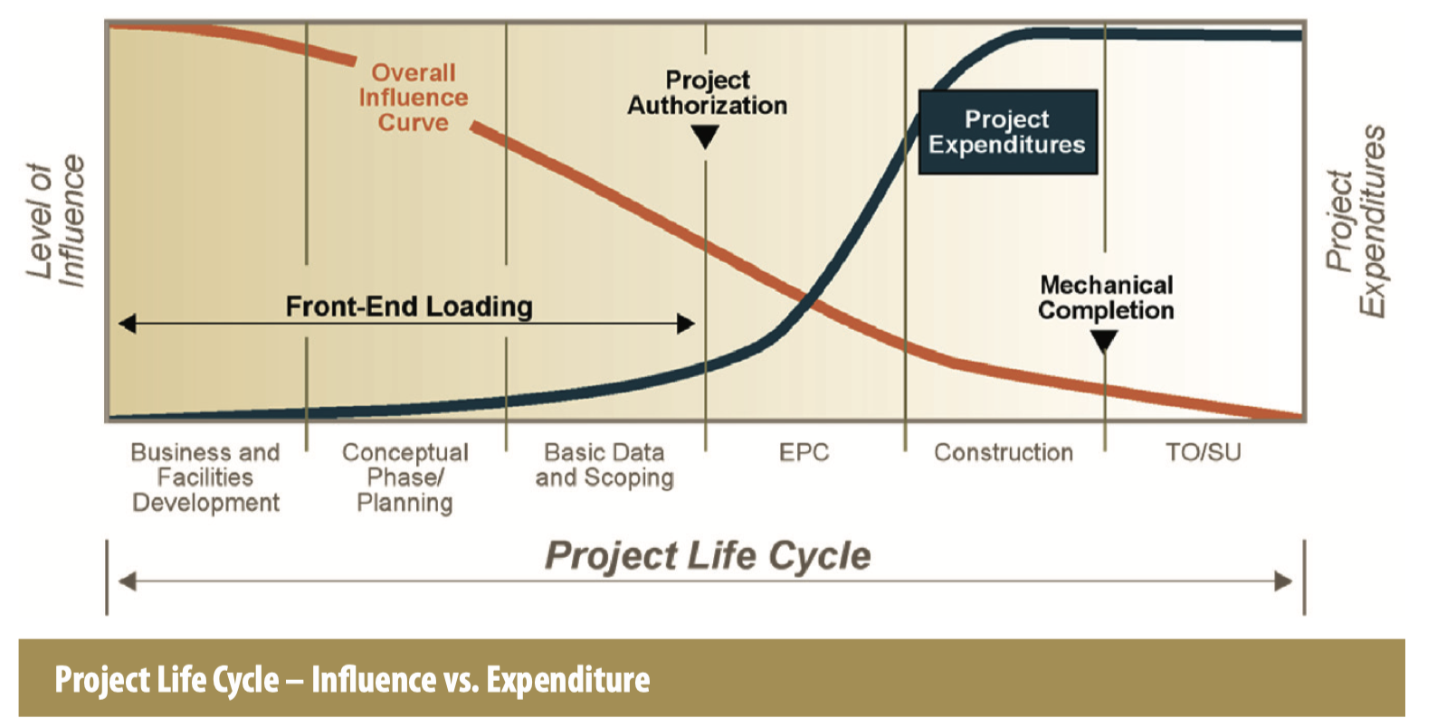
It is all to do with site investigation. We have sites, we investigate properties of the sites, we obtain data and we provide our interpretations of the data and give the results to our clients. Some time in the last century, a highly respected civil engineer, not necessarily to do with the offshore site investigations, but to do with site investigations in general, made a very important statement. He said that a company building any structure pays for a site investigation whether they do a site investigation or not. And the less they pay for site investigations the more it costs them. And that is a paradox. What it really means is that if you just start to build on a site without understanding the nature of the site and the way it will behave during its construction and operation you are going to face delays and much higher expenditures. Therefore you pay for site investigation if you do or do not carry one out, and the less site investigation you do the more it costs you. There are studies that say that every dollar spent on site investigation can be shown to save 10 dollars in the future. Site investigations make up 1% or 2% of project cost. Without site investigation, the risk that has not been assessed can cause all kinds of cost-over runs, over-engineering or delays.